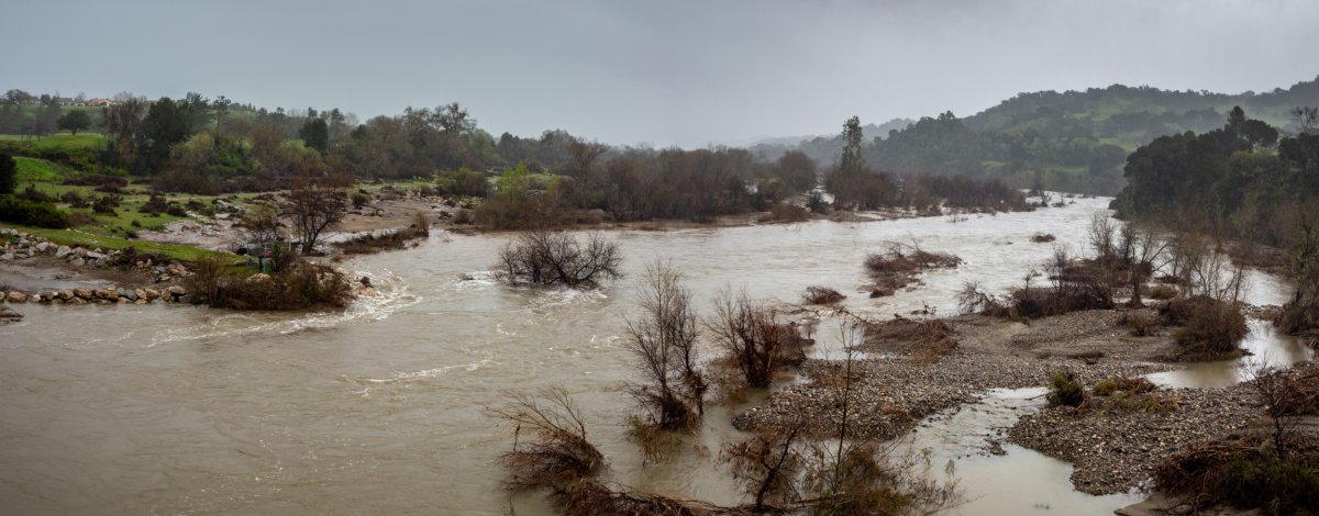
The massive amounts of rain and snow that have drowned California this month due to several atmospheric river storms have been captured in pictures taken from space.
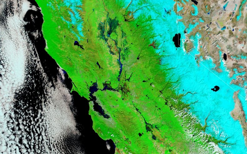
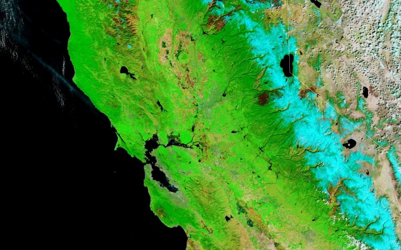
The Moderate Resolution Imaging Spectroradiometer (MODIS) on NASA's Terra satellite took false-color images of Sacramento and the San Francisco Bay Area on March 16 in both 2023 and 2022, showing the scale of rain and snow compared to this time last year.
The images show vegetation in light green, water cover in dark blue, and snow in light blue, highlighting how large the snowpack of the Sierra Nevadas is this year and flooded areas are in the wake of the stormy weather.
Atmospheric rivers are long, narrow streams of water vapor that move with the weather, bringing in vast volumes of rain—and snow, if it's cold enough. In fact, 30 to 50 percent of all the precipitation on the West Coast comes from a few atmospheric river events each year, the National Oceanic and Atmospheric Administration (NOAA) states.
Two successive atmospheric rivers hit California within days of each other, bringing with them flooding and other disruption to infrastructure.
Relentless... California is getting pummeled by multiple storms again. Huge snow build-up in the mountains with significant flooding unfolding across Central Cali and southern Sierra.
— Scott Duncan (@ScottDuncanWX) March 11, 2023
The moisture has come from Hawaii, a textbook Pineapple Express atmospheric river. pic.twitter.com/yb94d5ObTC
The map shows how much snow fell in recent weeks, which engulfed whole houses in some areas near Lake Tahoe.
Snow making a 3 story house look like a dollhouse. #cawx #California #snow #donnersummit pic.twitter.com/psEeF5wt4A
— B and J (@twodc) March 16, 2023
The Sierra Nevada mountains have experienced record-breaking levels of snow in recent weeks. According to data from the California Department of Water Resources (CDW), on March 13 the Southern Sierra Nevadas had a snowpack 257 percent greater than the average for that date and had more snow than the previously record-holding season in 1982-1983.
"California's snowpack is now an absurd 215% of the peak April 1 average," Colin McCarthy of the weather-tracking Twitter account @US_stormwatch, tweeted.
It’s a journey just leaving your house in Tahoe right now. (via 3030shred/TikTok) pic.twitter.com/PjoLw6Wyiu
— Active NorCal (@ActiveNorCal) March 1, 2023
The map also shows areas of flooding, which have increased hugely in the past few weeks due to the volume of rain falling across the state. Parts of Monterey County saw between 5 to 13 inches of rainfall on March 10 and 11, and the Sacramento River began to overflow over the Fremont Weir and into the Yolo Bypass, which covers about 60,000 acres of farmland and wildlife areas. As many as 276,000 Californians were without power as of March 14, and at least two people have been killed due to widespread flooding.
According to a recent NOAA forecast, 146 million people across the U.S., and 44 percent of the country are at risk for flooding—1.4 million people of which are at risk for major flooding.
We are happy California has a break in the rain. Here's🎥 from early in week showing Fremont Weir, Cache Creek Outlet Weir, & the Yolo Bypass doing exactly what they were designed to do & help manage #flood. Weirs are passive systems & move water when it reaches a specific height pic.twitter.com/8iJsNGBNbm
— CA - DWR (@CA_DWR) March 17, 2023
This extreme snowpack, combined with the rain across the state, has helped to alleviate the drought that has had California in its grips for much of last year.
U.S. Drought Monitor data reveals that the percentage of the state that is now free of drought has jumped from 26.84 percent on March 7 to 44.66 percent only a week later on March 14.
The snowpack is expected to further help the state with its drought, melting to water that will run down the mountains and refill reservoirs and rivers. However, depending on how fast the snow melts, this may lead to flooding, as the hard, dry soil may not absorb the meltwater, causing it to flow over the ground surface and cause flash floods.
"It's important to remember that timing and type of precipitation—rain vs. snow—is crucial for staying out of drought," Jacob Petersen-Perlman, a water resources geography expert and assistant professor at East Carolina University, previously told Newsweek. "Timing also matters: All the rain at once means that much of it will run off into the ocean instead of filling California's reservoirs."
The overarching megadrought—defined as being an extended period of low rainfall across several years—that has plagued California since around the year 2000, will take a lot more precipitation to life, however. This is because the groundwater levels have been depleted for decades, and need a slow and steady supply of water to refill.
"Surface water levels are only part of the picture—groundwater levels will likely still remain chronically low, because (rain or no rain) we deplete more groundwater than is replenished," Aakash Ahamed, a hydrologist and co-founder of the Water Data Lab, previously told Newsweek.
Therefore, it will take several years of above-average precipitation to fully pull the state out of drought once and for all.
"It's like we've spent down our bank accounts and it will take quite a while to rebuild. One year of good snowpack helps a lot, but is definitely not enough," Lara Fowler, an environmental and energy issues attorney and interim director of the Penn State Sustainability Institute at Penn State University, told Newsweek in February.
A trough will bring widespread rain and mountain snow across the Western U.S. into Monday with the heaviest snow in the Sierras and central Rockies. A significant storm will push onto the West Coast Tuesday with another round of heavy rain, heavy mountain snow, and high winds. pic.twitter.com/EFqOIsAtqZ
— National Weather Service (@NWS) March 20, 2023
In the meantime, California braces for yet another atmospheric river heading towards the coast this week, which is due to hit around Monday and Tuesday.
Do you have a tip on a science story that Newsweek should be covering? Do you have a question about atmospheric rivers? Let us know via science@newsweek.com.
Uncommon Knowledge
Newsweek is committed to challenging conventional wisdom and finding connections in the search for common ground.
Newsweek is committed to challenging conventional wisdom and finding connections in the search for common ground.
About the writer
Jess Thomson is a Newsweek Science Reporter based in London UK. Her focus is reporting on science, technology and healthcare. ... Read more
To read how Newsweek uses AI as a newsroom tool, Click here.